
The Forestry Toolbox is a centralized hub of resources designed to support municipal officials, sustainability staff, tree wardens, planners, and forestry professionals in advancing community forestry efforts. While many examples and references are drawn from Connecticut, the toolbox offers a structured framework and practical overview that can be applied in other regions, helping users approach community forestry in a strategic, data-driven, and informed way.
This is a planning toolbox and it is organized around a natural workflow, moving from assessment to planning while integrating community engagement at every stage. Implementation, following this planning process, should be adaptive to respond to changing conditions and evolving priorities.

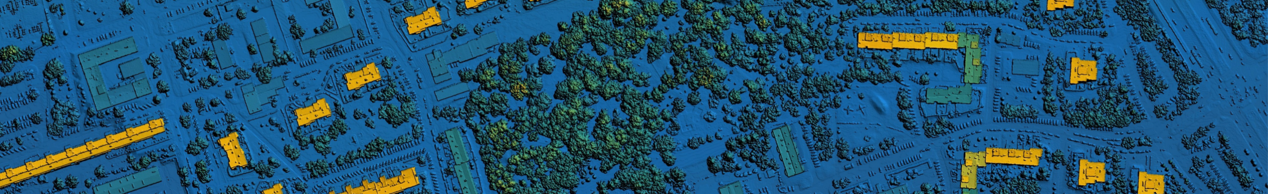
1.1 Tree Inventories
A structured tree inventory provides municipalities with defensible data for maintenance planning, risk mitigation, budgeting, liability tracking, and long-term canopy management.
A. Planning & Preparation
- Define its scope: Consider if the inventory will provide street, park, easement, or full municipal coverage.
- Collect data on:
- Location
- Species (common/scientific)
- DBH (diameter at breast height)
- Condition and integrity
- Maintenance needs
- Risk indicators
- Site characteristics (e.g., land use, planting space type, soil condition, evidence of compaction or site stressors)
- Complementary environmental metrics that enhance understanding of your tree benefits (e.g., temperature readings, air quality data, etc.), which can be documented using field tools like those featured in this community forestry toolkit
- Select an inventory methodology: full inventory, sample plots, or risk subsets.
- Adopt standardized taxonomies.
- Train staff in measurement protocols.
B. Field Data Collection
- Use GPS-enabled mobile devices.
- Measure using DBH tape, calipers, and clinometers.
- Map systematically and record each tree individually.
- Conduct periodic quality checks and spot validation.
C. Data Management & Integration
- Sync data to a centralized database.
- Integrate with Geographic Information Systems (GIS) platforms.
- Link inventory data to work order systems for pruning, removals, and hazard mitigation.
D. Analysis & Decision-Making
- Prioritize high-risk trees.
- Forecast pruning and removal budgets.
- Assess canopy distribution.
- Track trends in health and growth.
E. Ongoing Updates
Maintain a living database reflecting: new plantings, removals, condition changes, and completed tree work. Regular updates strengthen liability defensibility through documented action.
1.2 Software & Tools
The following provides an overview of several software options for tree inventories and tree benefit quantification. When selecting a tool, consider recommendations from other municipalities or states. For example, these links will take you to suggestions from organizations and agencies within Florida, Ohio, and Wisconsin. In addition to dedicated tree inventory platforms, complementary software can help you analyze broader forest or community conditions and ecosystem benefits (sometimes referred to as ecosystem services).
| Software / Platform | Category | Open Source / Proprietary | Description / Use Case |
|---|---|---|---|
| ArcGIS + Field Maps | Mapping | Proprietary / Paid | GIS platform for mapping, analyzing, and managing data (including tree inventories); integrates with mobile data collection via ArcGIS Field Maps. |
| QGIS + Field Maps / Plugins | Mapping | Open Source / Free | Open-source GIS software for mapping, analyzing, and managing data (including tree inventories); can integrate with mobile data collection through plugins or external apps. |
| Avenza Maps | On-the-go Mapping | Partly Free / Paid Tiers | Mobile app for offline mapping and geospatial data collection; useful for tree inventories and site assessments. |
| Epicollect5 | Form-based Mapping | Open Source / Free | Mobile and web platform for building custom forms and collecting field data (which could include tree inventory attributes). |
| i-Tree Tools | Tree Benefits | Free / Open Source | A suite of tools for modeling tree structure, canopy, and tree benefits such as pollution removal, carbon storage, and stormwater interception. |
| InVEST | Tree Benefits / Ecosystem Services | Open Source / Free | Modeling software to quantify and map ecosystem services like carbon storage, stormwater mitigation, and urban cooling provided by trees and natural areas. |
| SolVES | Tree Benefits / Ecosystem Services | Free / USGS Tool | Assesses social values of ecosystem services, including recreational and aesthetic benefits provided by urban and rural forests. |
| ArborNote | Tree Inventory | Proprietary / Paid | Mobile and web dashboard for collecting and managing tree inventory data and reports. |
| TreeKeeper | Tree Inventory | Proprietary / Paid | Cloud/web-based platform with mobile app to manage tree inventories, work orders, and inspections. |
| TreePlotter | Tree Inventory | Proprietary / Paid | Cloud/web-based platform used to collect and manage tree inventories, with dashboards and analytics. |
| Tree PlotterLITE | Tree Inventory | Free Lite Version / Data deleted on the 1st of every month | Lightweight tree mapping and inventory tool with mapping analytics; ideal for smaller-scale projects. |
| TreesCount! | Tree Inventory | Open Source / Free | Mobile app to record tree attributes, collect data for analysis, and export for GIS use. |
| EcoTeka | Ecosystem / Inventory | Open Source / Free | Web and mobile platform for managing inventories, environmental monitoring, and planning green spaces; also counts with ability to calculate ecosystem services and makes recommendations for re-vegetating corridors. |
Ultimately, you should select your software based on...

1.3 Tree Canopy Assessments
Tree canopy assessments should be done every 3-5 years and quantify existing canopy, plantable space and priority planting areas to support climate, infrastructure and community-centered planning. Learn more about how to conduct a tree canopy assessment through the overview below, and by accessing this U.S. Forest Service Guide. You can also check examples of tree canopy reports through the CT DEEP website for various Connecticut municipalities. We also encourage you to check out this compilation by the NY State Urban Forest Council for more action-oriented documents that specifically focus on tree and canopy outcomes and recommendations after completing an assessment.
Tree Canopy Assessment Process*
- Define Purpose & Scale: Municipality-wide or site-specific? Goals like heat vs. stormwater.
- Gather Spatial Data: LiDAR, high-resolution imagery, parcel boundaries, building footprints, etc.
- Map Existing Canopy: Manual digitizing or supervised classification.
- Calculate %:
Tree Canopy % = (Canopy Area ÷ Total Land Area) × 100 - Determine Possible Canopy: Potential tree canopy includes areas with available plantable space. This would include areas with buildings or water. Plantable space can include currently vegetated but non-treed areas, barren or open lands, and areas with types of impervious surfaces that could theoretically be converted. It is also important to consider how these interplay with existing zoning.
- Integrate Environmental, Socioeconomic, & Health Layers: Surface temperature (or other environmental variables), heat susceptibility (or susceptibility to other environmental concerns), and compounded socioeconomic indices. You can use national datasets or calculate your own weighted index. Some relevant sources for these are listed in our links and helpful resources page. For context on why this matters and a methodological approach for GIS-based data integration, refer to the Planning for Community Benefit section of this toolbox.
- Optional: Estimate tree benefits to quantity the benefits of current and possible tree canopy and its relationship to the other variables you are examining. A list of open-source software that can be used for this purpose is provided in our links and helpful resources page.
- Determine Priority Planting Spaces: Prioritize plantable spaces (high, medium, low) based on the integration of environmental, socioeconomic and health laters with the possible canopy dataset.
- Set Spatially Explicit Targets: X% to Y% growth goals in priority areas.
- Prepare Deliverables: These may include a report on municipality-wide canopy percentage, possible canopy percentage and planting goals; neighborhood maps and factsheets; methodology documentation; other.
(*Land cover categories to include in your assessment: Existing canopy, Grass/shrub, Impervious surfaces, Water, Buildings, Bare soil. Need more info on what is land cover? Confused on how it's different from land use? Visit this U.S. Forest Service page for a description.)

2.1 Forest Master Plans
This is your 10-20 year strategic plan for guiding forest management, funding and policy for your community. This document is distinct from a tree canopy report due to its action oriented nature. Below, we provide an overview of what to include in your plan but also encourage you to visit this thorough planning toolkit for more resources. Additionally, here are a few comprehensive forest master plans from various U.S. locations: Boston (MA), Columbus (OH), and NYC (NY). These plans were selected as examples because they integrate tree/canopy goals along with resilience planning and community-centered priorities.
A. Executive Summary, Purpose, & Assessment
- High-level overview of goals, priorities, and key actions, with a summary of the overall plan.
- Alignment, especially in defining the plan's purpose, with your local Plan of Conservation and Development (POCD) and any sustainability, climate, disaster preparedness, or resilience plans. UConn CIRCA maintains a list of local and regional plans for Connecticut that may be helpful.
- Define relevant assets and stakeholders, which may include parks, utilities, community organizations, and other partners.
- Establish the baseline conditions of your community forest, including current and potential canopy, inventory data, species diversity, maintenance backlogs, staffing and budgets,
tree ordinances or relevant regulations, and existing community stewardship programs.
B. Vision & Goals
- A co-defined guiding principle or overarching goal developed with key stakeholders. For example: “Proactive forest management that ensures canopy benefits are available to communities,” or “A forest with a variety of tree ages, sizes, and species developed through integrated forestry practices and nature-based solutions.”
- This guiding vision informs implementation and data-driven strategies such as prioritization, species selection, and planning approaches when Planning for Community Benefit.
- Grounding in civic processes is essential. Civic participation in forestry refers to the active involvement of community members in shaping, stewarding, and advocating for the planning, management, and long-term care of local trees and forested landscapes.
- Community input should be integrated alongside professional expertise to ensure balanced and informed decision-making. For ideas on participatory approaches, refer to the
Participatory Prioritization & Visioning section of this toolbox.
C. Measurable Objectives, Actions, & Responsibilities
Objectives should be clear, measurable, and connected to specific actions and responsible parties. Examples include:
- Canopy targets (e.g., 3+30+300: three trees visible from each home, 30% neighborhood canopy, and access to green space within 300 meters).
- Pruning cycle compliance.
- Reduction of tree risk backlogs.
- Species diversity thresholds such as 10-20-30 (no more than 10% of a species, 20% of a genus, and 30% of a family).
- Annual planting goals following recommended right tree, right place principles and best practices for tree planting
and long-term maintenance. - Updates to tree ordinances or protection policies, such as heritage tree preservation or tree removal guidelines.
Each objective should clearly identify associated tasks, timelines, and responsible departments or partners.
D. Implementation & Sustainability
Implementation strategies are often organized into phases. For example:
- Phase 1 (0-3 years): Foundation building
- Phase 2 (3-7 years): Program expansion
- Phase 3 (7-20 years): Long-term canopy growth and resilience
When designing these phases, consider whether your strategy addresses:
- Tree management and maintenance
- Planting and canopy expansion
- Policy and ordinance updates
- Funding mechanisms
- Strategic partnerships
- Long-term stewardship
- Contingency strategies for disturbances
- Processes for increasing civic participation in forest decision making
- Education and outreach (e.g., youth education, green-skills training, demonstration tours)
- Performance tracking and adaptive management
Regularly communicate progress, updates, and outcomes to maintain transparency and public support.
What is Performance Tracking?
Performance tracking is the systematic monitoring and evaluation of forest management actions and outcomes to measure progress, identify challenges, and inform adaptive decision-making. Regular monitoring (i.e., annual checks, detailed assessments every 2-3 years, and avenues for real-time staff and community reporting on storm damage, pests or maintenance needs) helps municipalities move from one-off planting projects to a sustained, adaptive forestry program.
- Suggested Indicators: Canopy coverage (%), tree condition, mortality rates, stewardship activities, ecosystem co-benefits, and any unanticipated disservices, pest outbreaks, infrastructure conflicts, etc.
- Schedule & Frequency: Annual check-ins, 3-year detailed assessments, and periodic updates aligned with the Forest Master Plan cycle.
- Community Reporting: Public dashboards, summary reports, and engagement tools to share progress and gather feedback.
Integrating this performance tracking ensures that forest management actions are evaluated, adapted and communicated, creating long-term benefits for both the environment and the community while mitigating risks or unanticipated negative impacts.

2.2 Planning for Community Benefit
Integrating public health and socioeconomic datasets into a GIS-based tree canopy assessment and planning effort enables municipalities to align tree canopy recommendations and forest management with areas experiencing higher heat exposure, respiratory illness rates, flooding vulnerability, or other environmental stressors. Using this data to identify how ongoing forest management can be paired with climate-mindful practices and nature-based solutions ensures that tree investments reduce risk, improve environmental health outcomes, strengthen resilience, and distribute forest benefits where they are most needed.
Planning for community benefits should be an iterative and integrated part of your tree canopy assessment and forest management process. As a result, the steps outlined in this section closely overlap with those discussed in the Tree Canopy Assessment and the Forest Master Plan sections. GIS analysis helps identify need; climate-mindful and nature-based implementation strategies translate that analysis into long-term, measurable community outcomes.
There are various methodologies for integrating socioeconomic and health data with environmental layers, including selecting variables based on how key stakeholders and community members define terms like risk and susceptibility. Consider this secondary data synthesis approach as one starting point. This framework can be expanded into more implementation-oriented tools, such as a shade and suitability analysis, species-site matching, or resilience-based tree allocation models that move from mapping disparities to designing solutions.
A climate-mindful, integrated forestry approach means canopy expansion is not only about planting more trees, but about planting the right trees in the right places for long-term resilience. This includes diversifying species to reduce pest vulnerability, selecting drought- or flood-tolerant species based on projected climate conditions, protecting soil health to improve stormwater infiltration and carbon storage, and integrating trees with complementary green infrastructure such as bioswales or permeable surfaces.
How to Select a Climate-Mindful or Nature-Based Practice
Use GIS findings, in combination with community input and local knowledge (gathered through Participatory Prioritization & Visioning), to refine priorities and guide implementation decisions by moving through these core questions:
- What risk or resilience gap are we trying to reduce?
These may include (but are not limited to) heat exposure, flooding, compacted soils, poor air quality, habitat fragmentation, and canopy disparities. Each can be addressed through targeted interventions such as large-canopy shade trees or shade corridors; riparian buffers and flood-tolerant species; soil remediation and structural soils; high leaf-surface-area species in high-traffic corridors; species diversification strategies; and strategic tree planting to close canopy gaps. - What site conditions determine feasibility?
Assess plantable space, soil quality, drainage, infrastructure conflicts, maintenance access, future development, and projected climate conditions. - Which practice provides multiple co-benefits?
Prioritize interventions that address more than one goal (e.g., shade + walkability, stormwater + habitat, diversification + pest resilience). - Do we have long-term management capacity?
Match species selection, design complexity, and monitoring expectations with available staffing and resources.
When these questions align, GIS analysis transitions from mapping canopy and resiliency gaps to designing climate-ready communities.
Why It Matters
- Uneven canopy distributions often mirror broader environmental burdens.
- Low-canopy areas frequently experience higher heat exposure and reduced environmental buffering.
- Gaps in key tree benefits (shade, air quality improvement, stormwater interception) translate into uneven community outcomes.
- Climate projections indicate that unmanaged disparities may intensify over time.
Planning Process & Monitoring
Use this step-by-step NOAA resource to support your planning process. It walks you through getting started, assessing exposure and risk, setting priorities, and developing actionable strategies. A typical data-driven planning process may include the following steps:
- Define objectives that align canopy goals with community resilience, public health, and long-term climate adaptation priorities.
- Identify canopy gaps and plantable space from your Tree Canopy Assessment.
- Compile demographic, environmental (heat, flooding, air quality, or other priority variables), and infrastructure layers based on priorities from your Forest Master Plan.
- Combine plantable space with weighted priority indexes to define resilience gaps and determine potential tree allocation for community benefit.
- Translate GIS findings into climate-mindful implementation strategies, including species selection, site design, maintenance planning, and cross-department coordination.
- Continue to track annual canopy distribution, environmental exposure metrics, and tree survival to adapt strategies over time.

3.1 Participatory Prioritization & Visioning
The What, Why and How
Working with communities for forest management entails intentionally partnering with community members, businesses, institutions and local leaders to co-determine how trees are planned, planted and maintained. This approach is essential because the most common way to achieve canopy goals is through private land.
Connecticut is no different; despite most of its forest being classified as urban, the majority is privately owned. Therefore, long-term success depends on broad public support, and traditional top-down planning does not always achieve it. Community engagement helps ensure that tree canopy goals reflect local values, contexts and community experience while building the trust and the foundation needed to sustain it over time.
In Practice
This means assembling a core team that includes trusted community liaisons; listening first through conversations, small group meetings and neighborhood visits; mapping canopy gaps alongside community knowledge; and inviting community members to become planning partners and meaning makers rather than passive recipients. It requires meeting people where they are, affirming their priorities, integrating professional expertise with local insight, and creating durable structures (such as anchor partnerships and shared commitments). For more information, consult this roadmap by the Vibrant Cities Lab.
Anchor Partners
An anchor partner should be a strategically selected community-based organization (CBO) with deep local roots and an established presence that can serve as a trusted liaison between residents and project leaders. Engage with a CBO through equal partnership, financial compensation, reciprocity and capacity building, while allowing time for relationship building.
Engage your CBO partner early in the planning process and collaborate on developing outreach materials tailored to the target community. Prioritize building visibility and trust by showing up consistently at local events, tabling, and participating in existing community spaces before initiating conversations about a forest master plan. For additional strategies, refer to this community toolbox.
Community Workshops
Community workshops provide structured opportunities for community members, municipal staff, forest professionals and partners to learn, share perspectives and collaboratively shape local tree initiatives through participatory processes that engage them in meaning-making and joint problem-solving. Community workshops can also serve as a gateway to broader civic participation, highlighting opportunities such as tree advisory boards, public hearings, volunteer programs and other forums where community input is needed to strengthen engagement and long-term stewardship.
Who Participates?
Workshops should not be designed solely for private property owners. Instead, they should intentionally recruit participants from across the community (including business owners, residents, community leaders, and youth) to support an “all lands, all hands” approach to forest stewardship. This model combines the U.S. Forest Service’s all-lands framework with a community-driven ethic of shared responsibility, recognizing that trees function across property lines and that long-term canopy success depends on coordinated action among public, private, and civic partners.
Municipal staff, tree wardens, and forest professionals should also be included to provide technical expertise on feasibility, maintenance, and regulations. Organizers should also be mindful, however, of existing trust dynamics; thoughtful facilitation, transparent communication, and trusted community partners can help ensure all voices feel valued.
Workshops also provide an opportunity to democratize knowledge: share your tree inventory results or other local data (such as thermal or air quality measurements), and instead of prescribing conclusions, allow community members to interpret the information through the lens of their own experiences. When designed thoughtfully, workshops move beyond one-way information sharing to interactive sessions. The following is a number of interactive, participatory actions one can employ in a community workshop.
Collaborative identification of priorities and assets directly on maps. Try this NOAA training →
Prioritize values like shade or air quality using posters or through a card-game discussion →
Respond to community-sourced images to gauge preferences via the photovoice method →
Technical experts and community members jointly generate solutions. See these examples on climate-mindful forestry→
Visioning: Moving from Input to Shared Direction
Participatory processes often identify needs and concerns. Integrating visioning into your community workshop adds an aspirational dimension to your workshop, by asking: What do we want our neighborhood forest to look, feel and function like in 10-20 years? Visioning builds shared ownership, aligns values and creates momentum toward implementation.
What is Visioning?
Community visioning is a structured yet creative process that helps communities collectively imagine a preferred future for their local forest. It translates values into guiding principles, planting priorities and long-term goals. Visioning can happen in many ways. Below are a few examples.
A designer can sometimes sketch ideas in real time as participants describe them. Seeing ideas take shape builds excitement and allows immediate input. Renderings can then be turned into professional drawings. Professional drawing example →
Participants create future scenes using images, maps or plant photos. This approach works especially well in multilingual and intergenerational settings. Collages can also be made digitally. Digital collage example →
Facilitated discussions are synthesized into a guiding statement (e.g., “Shade, safety and shared stewardship”) that anchors implementation decisions. Community statement example →
Participants review climate-ready and collectively meaningful species, discuss trade-offs, vote on preferences, and identify plausible planting sites. This approach connects to action. Tree palette example →
Groups compare possible canopy futures (minimal growth, climate-ready corridors, biodiversity focus) or what implementation of restoration and climate-mindful strategies would look like. Scenario building example →
Youth create drawings, models or digital concepts. Youth often identify overlooked priorities such as shade at bus stops or gathering spaces. Youth design example →
Don't forget! Planning for your community workshop or any participatory event should account for elements that detract from participation. According to this Yale report, these include language access, food insecurity, childcare needs, transportation challenges, location accessibility, and lack of trust. Proactively addressing these (through bilingual facilitators and translated materials, providing meals or snacks, offering youth programming, hosting events in community locations near public transit, and maintaining consistent engagement) can significantly boost participation. These are the essentials; partnering with a trusted CBO and engaging authentically with the community through ongoing participatory and visioning activities will take your efforts the rest of the way!
Anticipate conflict
During community interactions, be prepared for concerns regarding: Sidewalks, parking, visibility/safety, maintenance clarity, community distrust, and negative perceptions toward trees.
Follow up
Afterwards, communicate clear and transparent outcomes from your forest assessment, planning, and community engagement efforts by publishing summary reports, sharing annotated maps, and providing realistic implementation timelines.
Keep it up
Close the feedback loop by showing how community input shaped decisions and maintaining ongoing engagement beyond planning to sustain trust and honor commitments throughout implementation.
The Ultimate Outcome: Co-Governance
Co-governance is a shared decision-making model where responsibility and authority are distributed between municipal entities and community members; by fostering participatory processes, community visioning, and civic engagement, it moves beyond one-time consultation to build long-term partnerships, accountability, and enduring community ownership of forest stewardship.
What comes after planning?
After planning, as you move into implementation, focus on supporting communities to sustain and advocate for their local forests over time, ensuring that forest management creates lasting impact. You can do so by:
- Investing in local leadership: Training community members and youth to care for trees.
- Building stewardship networks: Supporting schools and faith-based organizations to share responsibility. Promoting collaboration between them and nearby neighborhoods.
- Promoting incentives: Providing free trees, mulch, or help cover irrigation costs. Promoting relevant federal and state programs that provide incentives for implementing conservation or climate-mindful practices (e.g., CT PA 490, NRCS EQIP, and NRCS CSP).
- Recognizing contributions: Highlighting exemplary stewardship through awards or media.
- Providing technical support: Offering access to service foresters, arborists and extension agents, especially those with relevant endorsements or certifications like the Adubon-approved bird habitat planning and ISA TRAQ.
- Prioritizing education: Fostering environmental literacy and tree care skills.
- Strengthening partnerships: Ensuring collaboration extends beyond grant cycles.

3.2 Outreach, Engagement & Education
Access our growing library of guides, tools, and educational materials for forest stewardship. These resources are designed to help you involve communities in monitoring, planning, and decision-making, while also building public awareness and support for long-term tree care.
Our resources focus on three key approaches:
- Outreach: One-way efforts to inform and raise awareness about forestry programs, policies, and opportunities. Examples include multimedia products and social media posts.
- Engagement: Two-way interaction that invites community participation in decision-making, priority-setting, or hands-on activities. Engagement emphasizes collaboration and listening to community perspectives to shape forestry actions.
- Education: Structured learning experiences that build knowledge and skills about trees, forests, and ecosystem management. Education can occur through workshops, classes, toolkits, demonstrations, or guided hands-on activities.
Multimedia & Social Media Products for Public Outreach
"How Urban Trees..." Video Series
A fun, animated series explaining how trees improve air quality, reduce heat and noise, and support biodiversity.
"Voices of Change" Documentary
A short film highlighting how urban and community forestry initiatives empower local communities.
Tree Benefits & Value Posters
Visually engaging posters illustrating the ecological and social benefits of trees.
"Voices of Nature" Virtual Exhibit
A multimedia showcase of women’s perspectives through quotes, photos and video interviews on the nature they encounter everyday.
"What Should I Do if I Hear Chainsaws in the Forest" Video
Tom Worthley, one of our Extension foresters, explains what you should do if you hear chainsaws in the UConn Forest or in a forest near your home.
Nature Benefits Marketing Toolkit (Coming Soon)
Digital media assets and print-ready materials to help communicate the value of nature.
Community Engagement Toolkits
Urban & Community Forestry Toolkit
Practical guides and activities for municipal staff, volunteers, and educators. This can be both an educational resource as well as a community activation tool through the monitoring of environmental variables in their communities.
Participatory Action Toolkit (Coming Soon)
Participatory actions from tree-benefit ranking exercises to nature photo-visual reactions to collect community input for the management of community forest resources.
Youth Education & Green Skills Building
K-12 Lesson Plans (Branch Out!)
Curated lessons for formal and non-formal educators teaching youth about forest ecology.
4-H Forestry Activities
This activity booklet was developed by UConn 4-H Forestry and includes a variety of hands-on activities designed to introduce youth to forestry concepts and skills.
Plant a Tree (Guide & Resource Hub)
Follow these research-based steps from UConn Extension Forestry to help you during your tree planting demonstration (includes a list of resources for the long-term care and maintenance of trees).
This toolbox is meant as a structured planning overview. While it simplifies many processes, it offers a starting point. It was developed through two complementary projects: one funded by the USDA Forest Service (Landscape Scale Restoration Program, Award No. 24-DG-11094200-283) supporting collaborative forest management in non-urban areas, and the other funded by the USDA Natural Resources Conservation Service (Award No. NR243A750003C122) focused on urban conservation. These projects are led by Dr. Mayra Rodríguez González (UConn Extension Forestry) and Jacqueline Kowalski (UConn Agricultural Extension), respectively. To learn more, visit our project StoryMap. For questions regarding this toolbox, contact Mayra at mayra.rodriguez_gonzalez@uconn.edu.